Wednesday, 26 June 2013

Why am I making films?

My research has taken a sharp turn into how we as humans understand a city as an environment in which to dwell. The theory as related to the reflection/reflexion dichotomy and Bourdieu’s ‘field’ and the ‘habitus’ inevitably led to a consideration of mapping as the end point of an interpretation and the starting point for new interpretation, this one at an arms length from the city itself and therefore potentially alienated or abstracted.

Maps mostly appear to take the form of a series of overlapping networks, breaking the city up into digestible and navigable chunks which, while no doubt useful for the pragmatic and essential everyday use of the city, begin to profoundly affect the way we think of the city and ultimately serve as an alienating device; a barrier between us and our environment. The wayfinding device as a quick route to an understanding begins to erode or entirely replace the urban form it is attached to.

The two films I have made so far have attempted to represent places (as opposed to spaces) within the city using other writers’ interpretations as a starting point. I then counterpoint this with my own interpretation of both the city and the text using moving image and sound. By ensuring that I return to the city itself in the act of filming and sound-recording, the end product (the filmic map) can therefore be said to be an interpretation of the city enriched by the text, rather than an interpretation of the text on it’s own.

The theory I have been looking at with regards to cartography suggests that map users rely on the map as someone else’s interpretation assuming it to be objective. The idea behind this approach was to openly accept this as the unavoidable inevitability of assuming another’s interpretation of a place and attempt to use this to enrich one’s own. What has happened, however, is that this process has made me aware of yet another pitfall.

The more I set about developing the techniques I needed to map in this way along with studying and deciphering the poetic interpretations which I was using as a springboard into my own, the more I got drawn into the objectification of the map, the production of a beautiful yet ultimately empty object. I got drawn into the game and lost the awareness that I was a mere player. I believed I was reflecting, while in actuality my reflexivity was running amok, unchecked. Somewhere, my ego kicked in and I became film-maker/cartographer, rather than the level headed researcher and observer I claim to be.

While it sounds like I regret this, and that I am criticising or even chastising myself, I’m glad that this has happened and that I have managed to step out of it without getting too carried away. I’ve developed a set of technical skills and acquired some physical equipment which I can return to at some point and use in a more intelligent and self-aware manner. Additionally, falling victim to the very things the theory and my own writing warns against I feel I have a better understanding of the fallacy of mapping, and the dangers which come with it.


After three or four weeks away from the books and journals, I now feel I can return to the theory, burying myself in it again before returning to the field smarter and more prepared to produce something worthwhile, helpful to others and free of personal pride and ego.


Tuesday, 14 May 2013

The plan: Walking to Aldergrove


“I’ve taken to long-distance walking,” extolls Will Self at the beginning of one of his ‘Psychogeography’ columns for the Independent, “as a means for dissolving the mechanised matrix which compresses the space-time continuum, and decouples human from physical geography.” Such lofty, high-academic language belies Self’s acute awareness of the modern-day psychogeographer’s position within society. “Most of the psychogeographic fraternity…are really only local historians with an attitude problem. Indeed, real, professional local historians view us as insufferably bogus and traveling - if anywhere at all - right up ourselves."

Despite this withering indictment I have resolved to ape Self’s psychogeographic technique of walking to airports, rather than surrendering to the hermetically sealed box of a car or the automated and undeviating route of a train or bus. This week I will walk from George Best City airport in East Belfast to Aldergrove International airport in the far-flung reaches of darkest Antrim. Admitting it out loud makes me feel embarrassed and concerned that people will not understand and call me mad, or a time-waster, dismiss me out of hand. However, since I first conceived it as a possibility two weeks ago I cannot rest until I have done it.

View Larger Map

Perhaps, as Self suggests, it is the simple idea of ‘The Quest,’ the ‘Epic Journey,’ casting myself as some sort of Tolkienesque hero who’s going to subvert the corrupt social order of car-dependent urbanism by wearing out my own shoe-leather and irreparably damaging my calf muscles in the process. Then again, more modestly I hope to achieve a more acute spatial awareness for the city in which I have lived my entire life , experienced as isolated and disembodied islands of Proustian events and the jumbled phenomena of my adolescence.

I have tried in recents years, and increasingly in recent months, to get to grips with the city by marinating in the historicism and literate narratives of Belfast. Pouring over books, records, novels and poetry, every time a place name is mentioned I reach for my laptop and locate it within Google Maps. Occasionally, if I’m lucky, it’s somewhere I know, or at least adjacent to a familiar spot. More often than not it’s in a part of the city I know only by name or reputation. The narrative is only given power if it becomes connected to space. Space then becomes place.

The epic walk, then, becomes cinematic. Reliance on a car or train becomes similar to a jumpcut, or fast-forwarding to the middle of the story and expecting to be able to follow. I wish to understand the city as a narrative progression beyond the five abstracted Lynchian elements. Paths, edges, districts, nodes and landmarks are all well and good; I wish to observe what connects them, the bleed between them, the ‘dark-matter’ of urbanism.

Since I’ve already invoked particle physics, I wish to declare a niggling worry; the process of recording the journey. I will be carrying with me a GPS logger, inscribing my route as a wiggling line of points across Google earth, while also making use of a video camera literally clamped to my hip. Will this act as the detector at the double-slit, abstracting the wave of my journey into a simple and predictable A to B route? Lets not get too carried away with that analogy, lest I get into trouble with my brother...

I’ll report back in a few days with the results of my anti-urbanist walk.

Wednesday, 3 April 2013

Belfast 400 Easter Festival

April 27th 2013 marked four hundred years since Sir Arthur Chichester read out Belfast’s Royal Charter received from King James I and granting Belfast’s town status, a moment immortalised by John Luke’s fantastically vibrant mural under the dome of City Hall. Belfast City Council took the opportunity of this date lying so near the long Easter weekend to throw open the doors of the City Hall and host an array of events celebrating this anniversary, all absolutely free to anyone who wanted to come along. For a self-confessed ‘Belfast geek’ (or should that be ‘enthusiast?’) such as myself this was an opportunity too good to miss.
I kicked off the weekend with Ruairí Ó Baoill’s’ ‘Hidden History’ archeological walking tour, taking a look at the often overlooked and invisible parts of Belfast’s past which it turns out extends far beyond the 400 year remit of the festival. We met at the front of the City Hall, where I had a few minutes to take in the extent of the celebrations before we set off. There was a collection of remarkable classic cars lined up beside Victoria, which a small sign informed me were courtesy of the ‘Banbridge Old Vehicle Club.’ On the other lawn, to Victoria’s right, were a crowd of ribbon dancers passing out ribbons to excited youngsters and encouraging them to join in. Crowds of people thronged around the entrance to the building, waiting for the doors to be opened for the host of events within.

I located Ruairí at the front gates, wearing in a high-visibility jacket and waiting with his son, similarly attired, who was to be his dad’s ‘glamorous assistant’ for the day. Each of us was given a copy of Thomas Phillip’s famous 1685 map of Belfast (often credited with being the first map of the town) annotated with the contemporary street names enabling us to orientate ourselves. The tour took us from the City Hall to Arthur Square, St George’s Church, Cotton Court off Waring Street and finally Writer’s Square in front of St Anne’s Cathedral. Along the way we were provided with snatches of history, unique insights, fascinating anecdotes, images of archeological digs and the beguiling objects found just beneath our feet.
As a perfect counterpoint to this tour, the next one kicked off at half two from the same spot. This one was the Architectural walking tour, hosted by PLACE and ably lead by Gary Potter of PLACE and the Future Belfast website. The route was similar to Ruairí’s, but provided a totally different set of insights into the city. Looking specifically at the existing buildings this was the visible history of Belfast, pointing out what there is to see even if we don’t see it in our day to day interactions with the city. I must confess that I feel rather ashamed to admit I had never looked up at the fantastic Art Deco facades in Ann Street; neither was I aware of the one original 18th century house still standing in Donegal Place nor the oddly incestuous nature of the competition to design the Albert Clock. Just some of Belfast’s architectural quirks highlighted on the tour.

After four hours of tours I really felt I’d earned my pint in the Washington Bar before heading home to warm up.

The next day I made my way to the Harbour Commissioner’s offices off Corporation Street. The unpleasant walk under the motorway and rail bridges, through eerily deserted car-parks, proved more than worth it to get a rare glimpse inside this magnificent building. The tour was hosted by a blue-badge tour guide, who informed us how woefully under-attended the tours had been over the weekend (perhaps a lack of advertising). This, however, made for a fascinating and intimate tour of this breathtaking building. I would urge anyone to include this on your list of places to visit in September’s European Heritage Open Days.

That night I attended the evening tour of the City Hall. Entering through the back gate (an entrance I had previously used only once before, on my wedding day), I waited patiently under the City Hall’s dome for a few minutes as my fellow tour-attendee’s gathered. The tour was guided by Michael Livingstone, an official guide for Belfast City Council, who started off by pointing out some historical artifacts and documents arranged around the reception area (including the original 400 year old copy James I’s charter). We ascended the grand stair case and all stood around the rotunda beneath John Luke’s previously mentioned mural. It was here it became clear this was not your standard historical tour. A man in 18th century garb was suddenly standing before us, animatedly reading a description of the old White Linen Hall. The tour continued in this way for just over an hour; a standard (if not fascinating) tour with these unexpected, humorous and at times moving dramatic counterpoints which breathed life and emotion into the history which surrounded us. All together an excellently put together tour/production which was over far too soon.

There were of course many more events over the weekend and I really do regret not making it to more; particularly the lectures in the great hall and the film screenings in the QFT and the Lyric Theatre. There was a fantastic atmosphere around the City Hall and in the city centre in general which personally proved a tonic for the city’s uncomfortable and unfortunate start to 2013.

Loving Belfast is never easy, but after a few difficult months the Belfast 400 festival gives us license to be proud again.

Sunday, 17 March 2013

Belfast Derivé

I've started doing a bit of situationist style 'drifting,' or 'derivé,' around Belfast. It's initially so I can get to know some unexplored areas of the city and revisit some places I haven't been in a long time. I'm trying to video each of the walk (by means of a subtly hidden camera in my lapel pocket to allow me to enjoy the dander, and avoid strange looks from people). I'll be adding these to the map as and when I can get them edited and uploaded to YouTube. One or two are already added, just click the lines on the map below to view them.

Enjoy!


View Derive in a larger map

Thursday, 7 February 2013

To Belfast - A short film about a city

Another video blog entry, a set of maps detailing the development of Belfast set to some music and poetry which illustrates my bitter-sweet relationship with the city along with the difficulty of maps for representation.


Music - 'Going to Your Funeral prt2' by The Eels, taken from the album 'Electro-Shock Blues'

Words - 'To Belfast' by Alan Gillis, taken from the book 'Somebody, Somewhere.' Please see previous 
 post (http://passoverinsilence.blogspot.com/2013/01/for-belfast-alan-gillis_24.html) for  words.

Sources - 
Bardon, J. & Bell, H.V. (1982) Belfast :an illustrated history. Repr with corrections edn, Dundonald: Blackstaff Press.
Bardon, J. & Conlin, S. (1985) Belfast: 1000 years. Belfast: Blackstaff.
Gillespie, R. & Royle, S.A. (2006) Belfast C.1600 to 1900 :the making of the modern city. Dublin: Royal Irish Academy.
Patton, M. & Ulster Architectural Heritage Society (1993) Central Belfast: an historical gazetteer. Belfast: Ulster Architectural Heritage Society.
Royle, S.A. (2007) Belfast, 1840 to 1900. Dublin: Royal Irish Academy.

Wednesday, 30 January 2013

Forgetting Belfast


This was originally published in the December 2012 issue of 'The Ulster Folk.' This is a highly edited version of a previous blog post, found here.

Northern Ireland is booming. ‘Our time, our place’ screams the slogan from every billboard, television and radio, not only across the province but also the UK and Ireland (a Dubliner recently told me he’s sick of hearing it). My question is who exactly is the ‘us’ of this slogan. Who’s time? Who’s place? The motivation behind redevelopments such as Victoria Square and Titanic Quarter along with future proposals such as Royal Exchange and the new University of Ulster appears to be either tourism or big business, the citizens of Belfast apparently not taken into account.

Belfast has never fully recovered from the conflict, still reading as a cultural waste-ground, and the current bout of redevelopment and investment doesn’t seem to be helping. But how did Belfast become a cultural void; forty years of ‘The Troubles’? A cursory look at the history of planning decisions in Belfast reveals it hasn’t all been caused by terrorism.

In the early 1960s Belfast was experiencing significant growth leading to a strained transport network. The Belfast Corporation developed a series of large-scale planning proposals including a massive urban motorway encircling the city core and a new urban masterplan. The timing of these plans corresponded with the beginning of ‘The Troubles,’ the explosion of violence resulting in a sharp decline in Belfast’s population and essentially rendering the proposals irrelevant.

Thanks to ongoing resistance from residents coupled with the escalation of violence the majority of these plans were shelved. However, a significant amount of the ‘slum clearance’ went ahead, as did phase one of the motorway; albeit in the altered sunken version of ‘The Westlink.’ These measures were enough to significantly blight inner north and west Belfast to this day, which a suspicious person may suggest was the intention of the plans in the first place in order to fragment these ‘troublesome communities.’

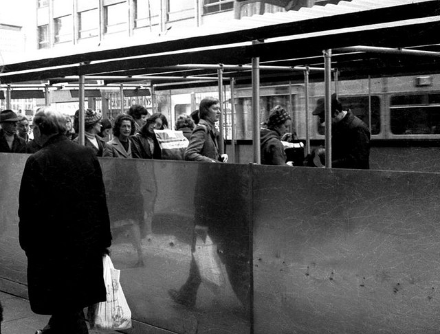
At the same time, due to co-ordinated paramilitary violence against businesses in the city, the infamous ‘ring of steel’ began to take shape around the city core. Beginning with informal military checkpoints on major routes, security measures intensified over the 1980s to the point where citizens who wanted to access central Belfast were made to queue up to pass through turnstyles in ten foot high steel walls, only being granted access once they had been frisked by military personnel. This led to a negation of ownership with regards to the city. The city centre was owned by someone else, be they military or paramilitary.
This removal of people from the city centre has created the cultural vacuum that is Belfast city centre today. The physical conflict has gradually died out since the ceasefires of the early 1990s, causing politicians to hail the success of the ‘peace process.’ The neutrality of the city centre, sterilised so as not to scare off investors, along with the segregation of inner city neighborhoods suggests that the conflict is far from gone.

In Belfast we are proud of our past, particularly with regards to shipbuilding and linen, yet the city centre is totally devoid of any official memorials or markers for the appalling atrocities committed in the past forty years. Oxford Street bus station, a building that became synonymous with ‘Bloody Friday,’ has been scoured from the street and replaced with an office complex. The gruesome descriptions from eyewitnesses on the ground that day are comparable to reports coming out of Kosovo and Syria in recent years. Yet this traumatic event goes unmarked, consisting only of individual memory and official documents.
A culturally empty urban centre is but a small problem, however, when we consider the memorials and plaques outside the city centre; each community choosing to memorialise specific events within their own areas. This causes misremembered and editorialised versions of these events to be passed down the generations, reinforcing the ‘us and them’ tradition. Local urban geographer Peter Shirlow describes this as “The criminilisation of the ‘other’ community and the failure to recognise suffering was endured within both communities...”

What we need is a meaningfully cultural city centre that goes beyond gaudy tourist attractions, glass shopping centres and the halcyon days of linen and shipbuilding and begins to speak of what we’ve been through, confronting us with how awful it was in our day to day civic engagements. This will enable us to move forwards and mark off how far we’ve come.

More than this, it will allow us to reclaim the city before someone else does.

Monday, 28 January 2013

Laganside - Belfast Sonic Poetry App

This article was published initially on the PLACE blog and then in the December 2012 edition of 'The Ulster Folk.'
It seems all too easy to criticise Belfast’s tired looking Langanside development, perhaps this is because it’s all too easy to forget how bad the post-industrial wasteland the banks of the Lagan were in the late eighties. It’s also easy to forget how incredible the aspirations of the Laganside Corporation were, given that it formed almost a decade before the Good Friday Agreement.

A new smartphone app called ‘Laganside’ highlights this dichotomy, enabling users to engage with this at times forsaken area; an area where Belfast’s aspirations, past, present and future, are made flesh. Developed by PhD music student John D’Arcy, the app was  launched on Culture Night 2012.

Taking on and surpassing the recent sonic arts trend in “digitised relational maps using embedded media,” ‘Laganside’ makes use of the contemporary epic poem of the same name, with a great reading by voice over artist Patrick FitzSymons. D’Arcy explains the reasons for choosing this particular piece by Belfast poet Alan Gillis. “Laganside doesn’t name particular places, but you know where he’s talking about, or you think you know and make your own connections based on your experience of Belfast, your personal history of it.” The app makes the academic fields of the sonic arts and poetry immediate and accessible, allowing the user to bridge the gap between the text and the space to which it refers.

The app’s unique design, by visual artist Gerard Carson, makes use of the smart phone’s ‘geo-location’ ability to track the user’s position along a three mile walk hugging the river. As the user approaches specific areas ‘soundscapes’ are triggered. A flurry of distorted music, sound effects and barely audible voices heightens the experience and lends further weight to both poem and locale. “The poem remains the same,” John explains, “but depending on your location your experience of it differs.” There are a number of other poems which can only be ‘collected’ by visiting locations along the route, something which should lend the app longevity, and perhaps suggesting that further routes could be added in the future.

The first soundscape I experienced was located at a platform jutting out into the river immediately behind the Waterfront Hall. As I ascended the short ramp to the platform a frenzy of noise overwhelmed me and the previously jovial voice in my ear took on a sinister air. I stood overlooking the river; several seagulls lined up along the steel balustrade eyed me resentfully before one by one taking off toward the lough; a train glided gently over the water; the city loomed behind. I felt consumed by sound, the  rhythm of the verse and my environment.

The meandering cadence of the poem, which describes a man’s walk along the regenerated riverfront with his ‘better half,’ gradually builds towards an understated yet profound climax. “Leaving me to find our way back to the streets, knowing I’ll never leave here, or come back again.” Fighting back the lump in my throat, the words resonated so strongly. From the grit and filth of the late eighties Belfast has surpassed itself, moving so fast the city is at times hard to recognise. The Laganside area is the embodiment of Belfast’s decline and regeneration; a city which never fails to impress and disappoint in equal measure.

‘Laganside - Belfast Sonic Poetry App’ is available for free on iTunes for iOS and Google Play for Android. Visit http://lagansideapp.com for information on the app or http://johndarcy.co.uk/ for other projects by John D'Arcy.